कृष्णा जिल्हा
Krishna district | |
|---|---|
District of Andhra Pradesh | |
 Clockwise from top-left: Kanaka Durga Temple, Kondapalli Fort, Buddhist remains in Ghantasala, Lord Andhra Vishnu temple, Prakasam Barrage, Manginagudi beach in Machilipatnam | |
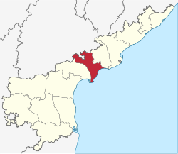
 Location of Krishna district in Andhra Pradesh | |
| गुणक (Machilipatnam): 16°17′N 81°13′E / 16.283°N 81.217°Eगुणक: 16°17′N 81°13′E / 16.283°N 81.217°E | |
| Country | India |
| State | Andhra Pradesh |
| Division | Krishna district |
| Headquarters | Machilipatnam |
| Tehsils | 50 |
| सरकार | |
| • District collector | Imthaj |
| • Lok Sabha constituencies | Vijayawada, Machilipatnam, |
| • Vidhan Sabha constituencies | 16 |
| क्षेत्रफळ | |
| • Total | ८,७२७ km२ (३,३७० sq mi) |
| लोकसंख्या (2011) | |
| • Total | ४५,१७,३९८ |
| • लोकसंख्येची घनता | एक्स्प्रेशन त्रुटी: अनोळखी / कार्यवाहक/किमी2 (एक्स्प्रेशन त्रुटी: अनोळखी round कार्यवाहक/चौ मै) |
| • Urban | ४०.८१% |
| • Urban density | एक्स्प्रेशन त्रुटी: अनोळखी / कार्यवाहक/किमी2 (एक्स्प्रेशन त्रुटी: अनोळखी round कार्यवाहक/चौ मै) |
| Demographics | |
| • Literacy | 73.74% |
| • Sex ratio | 992 |
| Vehicle registration | AP-16 (former) AP–39 (from 30 January 2019)[१] |
| Major highways | AH-45, NH-65, NH-221, NH-216 |
| संकेतस्थळ | krishna |
कृष्णा जिल्हा भारताच्या आंध्र प्रदेश राज्यातील एक जिल्हा आहे.
याचे प्रशासकीय केंद्र मछलीपट्टणम येथे आहे. या जिल्ह्याची रचना १८५९मध्ये झाली होती.
चतुःसीमा
तालुके
- ^ "New 'AP 39' code to register vehicles in Andhra Pradesh launched". The New Indian Express. Vijayawada. 31 January 2019. 2019-07-28 रोजी मूळ पान पासून संग्रहित. 9 June 2019 रोजी पाहिले.